Mount Wellington Hikes, Drive & Summit Views: Visitor Guide
There’s a reason Hobart locals glance up at the mountain before they step out the door — Kunanyi / Mount Wellington doesn’t just frame the city skyline, it dictates the weather, the mood, and the day’s plans. Whether you’re planning a hike, a drive to the summit, or simply wondering what the fuss is about, this guide lays out everything you need to know in one place.
Height: 1,271 m (4,170 ft) ·
Location: Hobart, Tasmania, Australia ·
Drive from Hobart CBD: 21 km / 30 minutes ·
Summit temperature difference: Up to 10°C cooler than city ·
Hiking time (return): 4–6 hours on popular trails ·
Park established: Wellington Park, 1982
Quick snapshot
- Mount Wellington rises 1,271 m above sea level (Mountain-Forecast (weather data provider))
- Pinnacle Road is open to private vehicles (Discover Tasmania (official tourism site))
- Multiple hiking trails cross Wellington Park (Mt Wellington Explorer (park operator))
- The summit can be 10°C cooler than Hobart city (based on travel reports, not official BoM data) (Mountain-Forecast (weather data provider))
- Exact number of daily visitors — no official counter
- Future road closure policies beyond current season
- Long-term weather pattern changes affecting access
- Exact temperature difference between summit and city — sourced from travel guides, not official BoM data
- Cloud coverage frequency — reports vary; no long-term visibility data published
- Summer (Dec-Feb) offers the clearest summit views; cloud often obscures the panorama in other seasons (A Globe Well Travelled (travel guide))
- Check the Pinnacle Road status and summit webcam via the City of Hobart (municipal authority) before you go
Seven key specs, one pattern: the mountain’s identity is shaped by its elevation, rock, and history — all of which affect what you’ll experience.
| Label | Value |
|---|---|
| Alternative name | kunanyi |
| Elevation | 1,271 m (4,170 ft) |
| Prominence | 1,271 m |
| Location | Hobart, Tasmania, Australia |
| First recorded climb | 1798 (George Bass, Matthew Flinders) |
| Rock type | Jurassic dolerite |
| Managed by | Wellington Park Management Trust |
How long does it take to walk Mount Wellington?
Difficulty and trail options
- Pinnacle Track / Zig Zag Track – The most direct route from The Springs to the summit, rated hard due to steep climbing and uneven surfaces. One-way distance about 4.7 km with significant elevation gain (Mt Wellington Explorer (park operator)).
- Organ Pipes Track – Leads to the base of the mountain’s iconic dolerite columns; shorter but still challenging (A Globe Well Travelled travel guide).
- Summit via Fern Tree Park – 4.7 km one way, described as having significant climbing, steps, and uneven surfaces (Mt Wellington Explorer park operator).
Starting points and recommended routes
- From The Springs (car park) – Pinnacle Track / Zig Zag Track: 4–6 hours return.
- From Fern Tree Park – Summit walk via Pillinger Drive, Fern Glade, Radfords, Pinnacle and Zig Zag tracks: allow up to 8 hours return.
- Shorter options – Organ Pipes Track: 2–3 hours return; shorter walks around The Springs take under an hour.
Preparation and safety tips
- Always check the Bureau of Meteorology (Australia’s weather authority) for latest summit observations (station 094087).
- Warm and waterproof clothing is essential even in summer — the summit is typically 10°C cooler than Hobart and can shift quickly (Discover Tasmania official tourism site).
- For footwear, consider a pair from our guides on Best Hiking Boots for Wet Trails or Best Hiking Shoes for Wet Climate — wet rock and mud are common on the trails.
The implication: time on the mountain depends as much on route choice as on weather readiness.
The mountain’s weather can flip from sunshine to snow within an hour. Even on a clear Hobart morning, the summit may be fogged in. The trade-off: you get a genuine alpine experience without leaving the city limits.
Why is Mount Wellington famous?
Aboriginal significance and the name kunanyi
The mountain is known as kunanyi in the language of the Muwinina people, the original custodians. The dual name officially recognises this heritage. For the Aboriginal community, the mountain is a place of deep cultural significance — not just a landmark but a living part of identity.
Panoramic views of Hobart and the Derwent
From the summit, the entire Hobart waterfront, the Derwent estuary, and the Tasman Peninsula unfold below. On clear days, the view stretches to the Southern Ocean. The city’s skyline, the harbour, and the surrounding hills create one of Australia’s most photographed urban vistas (Discover Tasmania official tourism site).
Unique alpine environment and rock formations
The cap of Jurassic dolerite forms the Organ Pipes, dramatic columns that rise near the summit. These geological features attract climbers and photographers alike. The mountain also hosts vegetation zones that transition from temperate rainforest to alpine heath (Discover Tasmania official tourism site).
Role in Hobart’s identity
Locals use the mountain as a weather gauge: if the cloud cap is low, expect a cool, damp day. The mountain’s silhouette appears on everything from beer labels to tourism logos. It is the defining natural feature of the city.
The pattern: the mountain’s fame is not just aesthetic — it’s functional, embedded in local identity and daily life.
Can you still drive up to Mount Wellington?
Pinnacle Road access and conditions
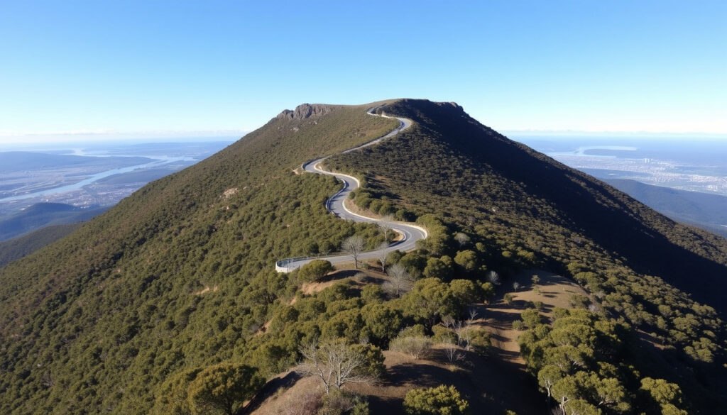
Yes, Pinnacle Road is open to private vehicles year-round, weather permitting. The road climbs 21 km from Hobart’s CBD to the summit car park. No fee is charged, but restrictions apply during snow, ice, or high winds (Discover Tasmania official tourism site).
Vehicle requirements and restrictions
Standard cars are fine — no 4WD required. However, buses and caravans over 7 metres are prohibited beyond The Springs. Cyclists are allowed, but the climb is steep (about 1,271 m vertical gain). The Desire Lines Cycling Club (local cycling group) describes a route using the Big Bend fire trail then the final 2 km on tarmac.
Current road status and closures
Check the City of Hobart webcam page for Pinnacle Road status and summit webcam before you leave. During winter, the road may close at short notice. The Bureau of Meteorology provides live summit observations.
The road can close for hours or days during snow events. Drivers who ignore closure signs risk fines and towing. The penalty for getting caught out: a long, cold wait.
The catch: driving access depends on weather that can change in minutes.
Is Mount Wellington worth it?
For most travellers, the answer is a clear yes — but it depends on your priorities. Here’s the breakdown.
Upsides
- Free access — no entry fee for drive or most walks
- Stunning summit views on clear days
- Excellent hiking for all fitness levels
- Unique alpine environment close to the city
- Cycling and bus options available
Downsides
- Weather is unpredictable — clouds can ruin the view
- Summit has limited facilities (no café on top)
- Road closures during snow/ice can block access
- Wind can be fierce even on calm days
- Crowds on weekends and holidays
For anyone who values a genuine wilderness experience within 30 minutes of a city, the mountain delivers. The trade-off is the weather lottery: on a bad day, you’ll see only fog. On a good day, you’ll remember it for years.
The pattern: worth it depends on your tolerance for weather risk — the payoff is high, but only if you come prepared.
What are some interesting facts about Mount Wellington?
Geological formation
- The mountain’s cap is Jurassic dolerite, formed about 180 million years ago (Discover Tasmania official tourism site).
- The Organ Pipes are a striking example of columnar jointing — nature’s own architecture.
Climate and weather records
- The summit often sits in a cloud layer while Hobart basks in sun; temperature inversions are common.
- The Bureau of Meteorology records snowfalls at the summit several times each winter.
- Winds over 100 km/h are not unusual.
Flora and fauna highlights
- The mountain is home to endemic species such as the mountain butterfly (Oreixenica ptunarra).
- Vegetation ranges from wet eucalypt forest to alpine heath, creating distinct ecological zones.
Human history
- The first recorded European climb was by George Bass and Matthew Flinders in 1798.
- Wellington Park was established in 1982 to protect the area.
- A telecommunications tower sits near the summit, used for broadcast and emergency services.
The mountain’s geology and climate create a microcosm of Tasmania’s wild side — accessible to anyone who can drive or walk. For a tourist, it’s a crash course in alpine ecology without needing an expedition.
The implication: these facts aren’t trivia — they explain why the mountain feels different from anywhere else near Hobart.
Steps for planning your visit
- Check the summit webcam – Use the City of Hobart webcams to see current conditions.
- Review Pinnacle Road status – Same page shows if the road is open.
- Choose your activity – Drive, hike, cycle, or take the Mount Wellington Explorer Bus shuttle service.
- Pack layers – Assume the summit will be 10°C colder and windier.
- Set a turn-back time – If hiking, allow enough daylight for the return.
The pattern: preparation is the difference between a great trip and a wasted one.
What we know and what’s uncertain
Confirmed facts
- Mount Wellington is 1,271 m high
- Pinnacle Road is open to cars
- There are multiple hiking trails
- The mountain is a popular tourist attraction
- Wellington Park is a protected area
What’s unclear
- Exact number of daily visitors
- Future road closure policies
- Long-term weather pattern changes
- Exact temperature difference between summit and city — based on travel reports, not official BoM data
- Cloud coverage frequency — no long-term visibility data published
“Kunanyi / Mount Wellington is a place of great cultural importance to the Aboriginal community. It’s not just a mountain — it’s a living story.”
Aboriginal community representatives (cultural custodians)
“We advise all visitors to check the road status and weather before setting out. Conditions on the mountain can change in minutes.”
Wellington Park Management Trust (park authority)
“The mountain draws over a million visitors a year. It’s the single most popular natural attraction in the Hobart region.”
Hobart City Council (municipal government)
For a traveller from Hobart, the choice is clear: check the road status and pack layers, or risk a wasted trip. The mountain rewards preparation with views and experiences that no city can replicate. For those who come ready, kunanyi / Mount Wellington delivers one of Australia’s most accessible alpine encounters.
thelifeofpy.com, tripadvisor.com, instagram.com, ventusky.com, metservice.com
Frequently asked questions
What is the best trail for beginners on Mount Wellington?
The Organ Pipes Track is a good introduction — about 2–3 hours return with moderate difficulty. The summit walk is best left for experienced hikers.
Are dogs allowed on Mount Wellington?
Dogs are permitted in most areas of Wellington Park but must be on a lead and under control. Check park signage for specific restrictions.
Can I cycle up Mount Wellington?
Yes, cyclists are allowed on Pinnacle Road. The climb is steep – about 1,271 m elevation gain – so it’s a serious ride. The Desire Lines Cycling Club has route notes for an approach via the Big Bend fire trail.
Is there a shuttle bus to the summit?
Yes, the Mount Wellington Explorer Bus runs from Hobart to the summit with multiple stops. It’s a popular way to combine a one-way hike without needing a car.
What should I wear when visiting Mount Wellington?
Layers are essential. The summit is often 10°C colder than Hobart and windy. A waterproof jacket, warm mid-layer, and sturdy shoes are recommended. For wet trails, see our guide on best hiking boots for wet trails.
Are there toilets on the mountain?
Toilets are available at The Springs picnic area and at the summit car park. No facilities along the trails themselves.
How can I check the road status before driving?
Visit the City of Hobart webcam page for the latest road conditions and summit views. The page also lists any closures.
More related posts
 Gerard Way: Biography, Personal Life, and Career
 MCoBeauty at BIG W: Prices, Range & Sale Guide (2025)
 Patrick Wilson: Biography, Movies, Wife, Net Worth, and More
 Water Filter System Guide: Best for PFAS, Chlorine & Cost
 Perth Airport Arrivals – Live Status, Terminals & Pickup Guide
 Melbourne Victory FC: History, Rivals and Grand Final Wins
 Chennai Super Kings vs Punjab Kings Match Scorecard – IPL 2024 Full Result and Stats
 Chicken and Rice Recipes: Flavorful One-Pot & Global Twists